Here's a map of Southern Ghana.
This covers all the church units, and most of Ghana's population.
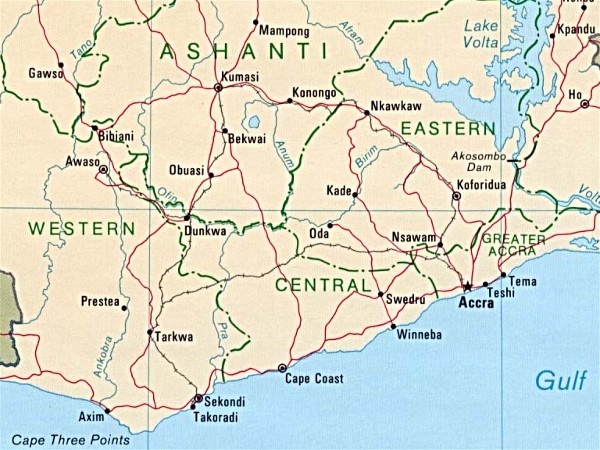
Here's a map of Southern Ghana.
This covers all the church units, and most of Ghana's population.
A list of the four trips that produced the pictures for this website update:
September 23-24 Kumasi
We left Accra at about 10:00 am and drove the main highway to Kumasi. We arrived about 4:00 pm--six hours with lunch on the road to go about 165 miles. There was lots of traffic on the two lane road and frequent delays. We were able to find the Stake Center and Elder and Sister Anderson's apartment. We stayed with the Anderson's. On Saturday, we did church audit and financial process training until 1:30 pm. We then drove home, through even worse traffic, arriving well after dark at about 8:00 pm. With pedestrians, potholes and other drivers, driving after dark is scary, even for Elder Markham.
October 8-9 Cape Coast
We left Accra about 8:30 am and drove the main highway through Winneba to Cape Coast, arriving about 1:30 pm. It is only about 120 miles, but the highway is being widened and improved for more than half the way, so the route is often dirt and mud. It was raining. The road was so rough that Sister Markham pinched a nerve in her hip and was bothered by that for a couple of weeks. In Cape Coast, we visited Cape Coast Castle, infamous for the slave trade conducted there. We found the Stake Center. A member there guided us to the Ola University Ward building where our training would be the next day, then to Elder and Sister Vernon's house where we stayed. We met with the Stake Presidency Friday afternoon, then met the Vernons at Coconut Grove Resort Hotel for dinner. It is right on the ocean and very nice. We made a reservation to stay there the next week on our way to Takoradi. We did our training on Saturday until about 2:00 pm then drove home. Pres. Appiah suggested we take an alternate route that loops north of the main road. It is a "country" drive that goes through Swedru. It was better than the construction and yielded many interesting sights. We were home by 6:30 pm.
October 15-16 Takoradi
Once again we left Accra heading west on Friday morning. This time Elder and Sister Whisenant were with us. They are full time missionaries assigned as the Public Affairs Directors for West Africa. They were doing Regional Public Affairs training in Cape Coast on Saturday. We took the scenic route this time to avoid the construction. We got to Coconut Grove, about ten miles past Cape Coast, a little after noon. We relaxed by the beach and ate lunch with the Whisenants. Then we left our key with them--they were staying with the Vernons whom we were all meeting for dinner--and drove to Takoradi. Takoradi is about 50 miles beyond Cape Coast on the same highway. The highway between Takoradi and Cape Coast is very good, the best we've seen in West Africa. We found the Stake Center where our training would be, and we visited the mother of a young man who is a friend of our son Sammie in Virginia. We then went back to Coconut Grove for dinner with the Vernons and Whisenants. After a relaxing night in a nice hotel, and a great breakfast, we drove back to Takoradi for the training session. We left Takoradi a little after 1:00 pm, picked up the Whisenants in Cape Coast about 2:15 and headed home on the scenic route. We had smooth sailing until just outside Accra, where a fatal traffic accident had stopped traffic. We got home about 7:30 pm.
October 23 Assin Foso
Assin Foso is a small city on the north-south highway between Cape Coast and Kumasi. It is about half way to Kumasi. Since it is not a tourist stop, the hotels are poor. Therefore, we decided to do a one day trip. We left home at 5:45 am, took the scenic route toward Cape Coast, cut over a "back road" shortcut to the Cape Coast-Kumasi Highway, and got to Assin Foso at 10:03 am, three minutes late for our meeting. After the training we followed the bread crumbs home, arriving at 6:30 pm. We were both traveled out.Click this button to return to the previous page.